

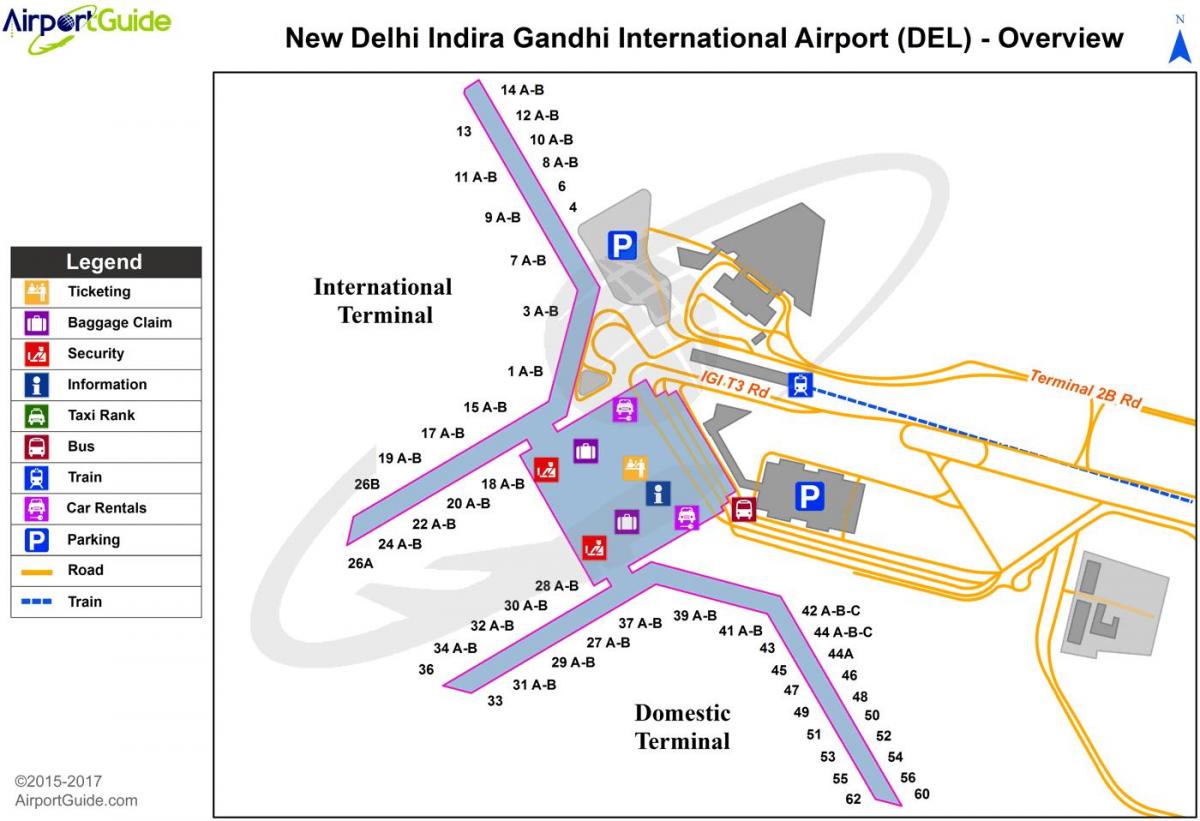
You can find on this page the New Delhi airports map to print and to download in PDF. The New Delhi airport map presents terminals and gates of the international airport of New Delhi in India.
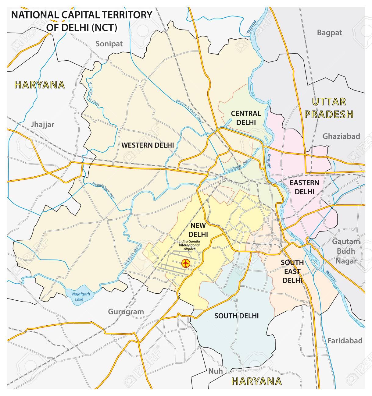
The New Delhi airports map shows all the airports around New Delhi. This airports map of New Delhi will allow you to determine which airport you will used to leave New Delhi in India. The New Delhi airports map is downloadable in PDF, printable and free.
Indira Gandhi International Airport (IGI) serves Delhi for both domestic and international air connections, and is situated in the south-western corner of the city. In 2005-2006, IGI recorded a traffic of more than 20.44 million passengers, both Domestic and International. Heavy air traffic has emphasised the need for a secondary airport, which is expected to be Taj International Airport near Greater Noida, alongside the Delhi-Agra highway as its shown in New Delhi airports map.
The old Palam Airport is actually Indira Gandhi Airport Terminal 1. When Terminal 2 was already built, the airport was renamed to Indira Gandhi International Airport as its mentioned in New Delhi airports map. Palam Airport, which is the current Terminal 1 at DEL Airport it is still a domestic terminal, as Palam Airport was the domestic airport of the area, the New Delhi Domestic Airport. Indira Gandhi International Airport is the main airport in New Delhi city. Very important and big airport that serves both international and domestic flights. Its terminal 1 was once Palam Airport.
Safdarjunt airport Presently it is not used as commercial airport as you can see in New Delhi airports map. It is only used for VVIPs choppers, Governmental dignitaries, Diplomats etc. It used to be known as Willingdon Airfield started operations in 1929 during the British Raj. Once serving as New Delhi main airport until 1962, it is now called Safdarjung Aiport, and has been officially closed since 2002. In 2001, after 9/11 and the success of the larger, more convenient Indira Gandhi International Airport, the Ministry of Home Affairs decided to close Safdarjung to the public and use it as a secure emergency getaway option for the President and the PM.

The map of New Delhi airport presents the main international airport of New Delhi. This international airport map of New Delhi will allow you to determine by which terminal and gate you will arrive or leave New Delhi in India. The airport New Delhi map is downloadable in PDF, printable and free.
Indira Gandhi International Airport (IATA: DEL, ICAO: VIDP) is the primary international airport of the National Capital Region of New Delhi, India, situated in South-West Delhi, 16 km (10 mi) southwest of New Delhi city centre as its shown in New Delhi international airport map. Named after Indira Gandhi, the former Prime Minister of India, it is the busiest airport in India. With the commencement of operations at the new Terminal 3, Delhi Indira Gandhi International Airport has become India and South Asia largest and one of the most important aviation hub, with a current capacity of handling more than 46 million passengers and aimed at handling more than 100 million passengers by 2030. Along with Mumbai Chhatrapati Shivaji International Airport, it handles more than half of the air traffic in South Asia. The airport operator, New Delhi International Airport Private Limited (DIAL), is looking to make the airport the next international transit hub.
Spread over an area of 5016 acres of land , New Delhi international airport serves as the primary civilian aviation hub for the National Capital Region of India. It was previously operated by the Indian Air Force until its management was transferred to the Airport Authority of India as its mentioned in New Delhi international airport map. In May 2006, the management of the airport was passed over to Delhi International Airport Limited (DIAL), a joint venture led by the GMR Group, which also has the responsibility for the airport ongoing expansion and modernisation. In 2011-12, the airport handled 35.88 million passengers and the planned expansion program will increase its capacity to handle 100 million passengers by 2030. The new Terminal 3 building has had the capacity to handle an additional 34 million passengers annually since the start of the 2010 Commonwealth Games. Terminal 3 is the world's 8th largest passenger terminal
In September 2008, the airport inaugurated a 4.43 kilometre-long runway. In 2010, Indira Gandhi International Airport (IGIA) was conferred the fourth best airport award in the world in the 15–25 million category, and Best Improved Airport in the Asia-Pacific Region by Airport Council International (see New Delhi international airport map). In 2011, the IGIA was ranked the second-best airport in the world in the 25-40 million passengers category, again by Airport Council International. New Delhi Airport has two parallel runways and a near-parallel runway: Runway 11/29 (14,852 ft (4500m)) with CAT IIIB ILS on both sides and the main runway 10/28 (13,452 ft (4,100 m)) as well as an auxiliary runway 09/27 (12,500 ft (3,800 m)). IGI Airport is the home of several Indian airlines including Air India, Air India Regional, IndiGo, JetLite, SpiceJet, Jet Airways, Kingfisher Airlines, GoAir use IGI Airport as their secondary hub. Approximately 80 airlines serve this airport. At present there are two active scheduled passenger terminals, a dedicated Hajj terminal and a Cargo Terminal.