

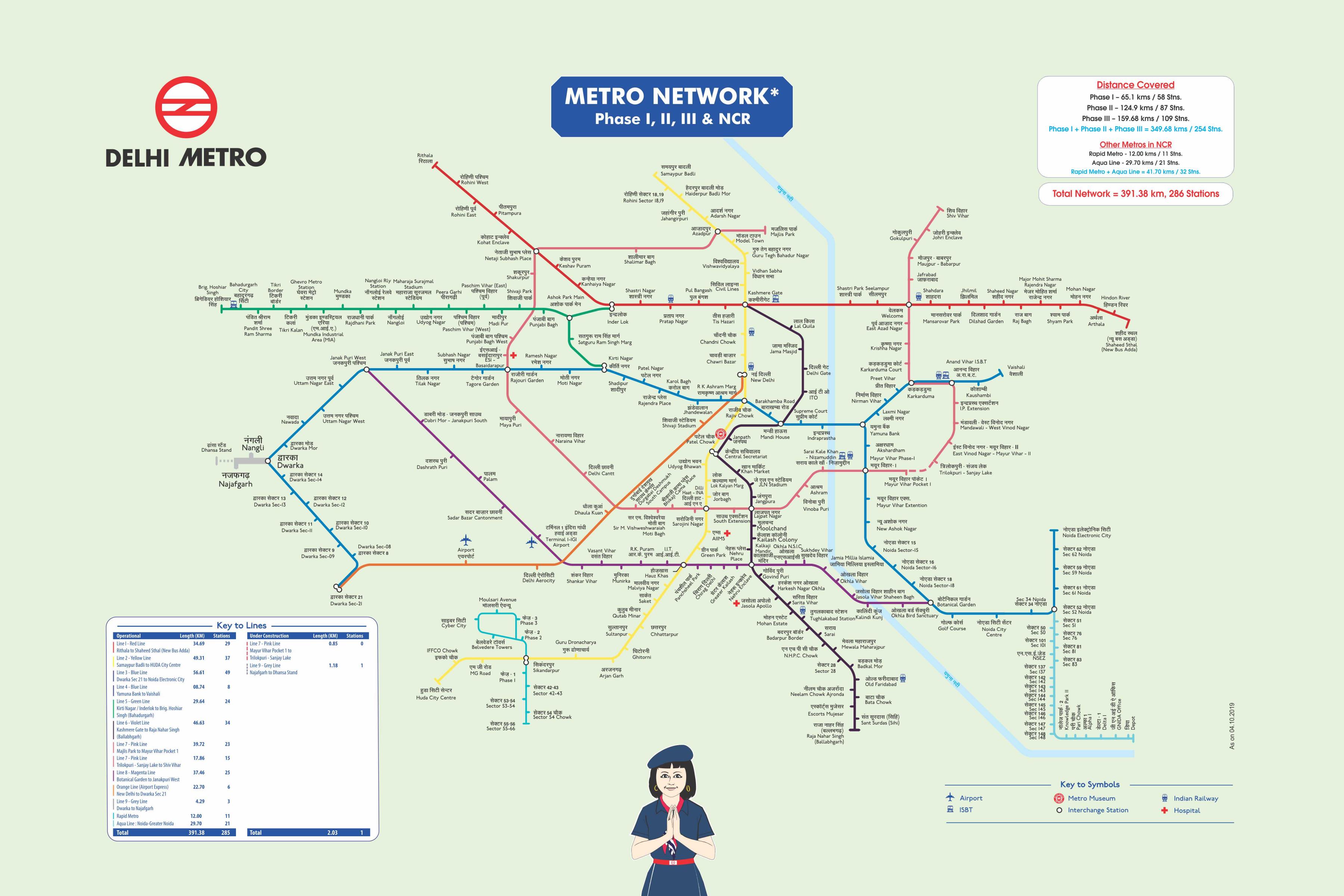
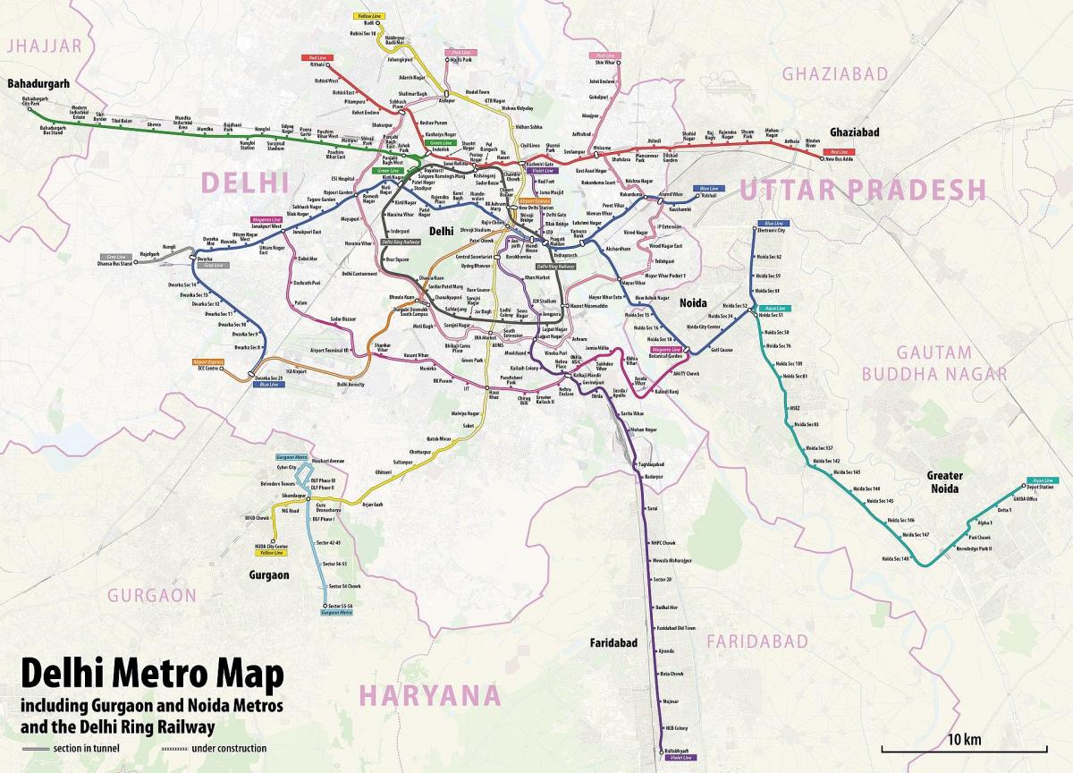
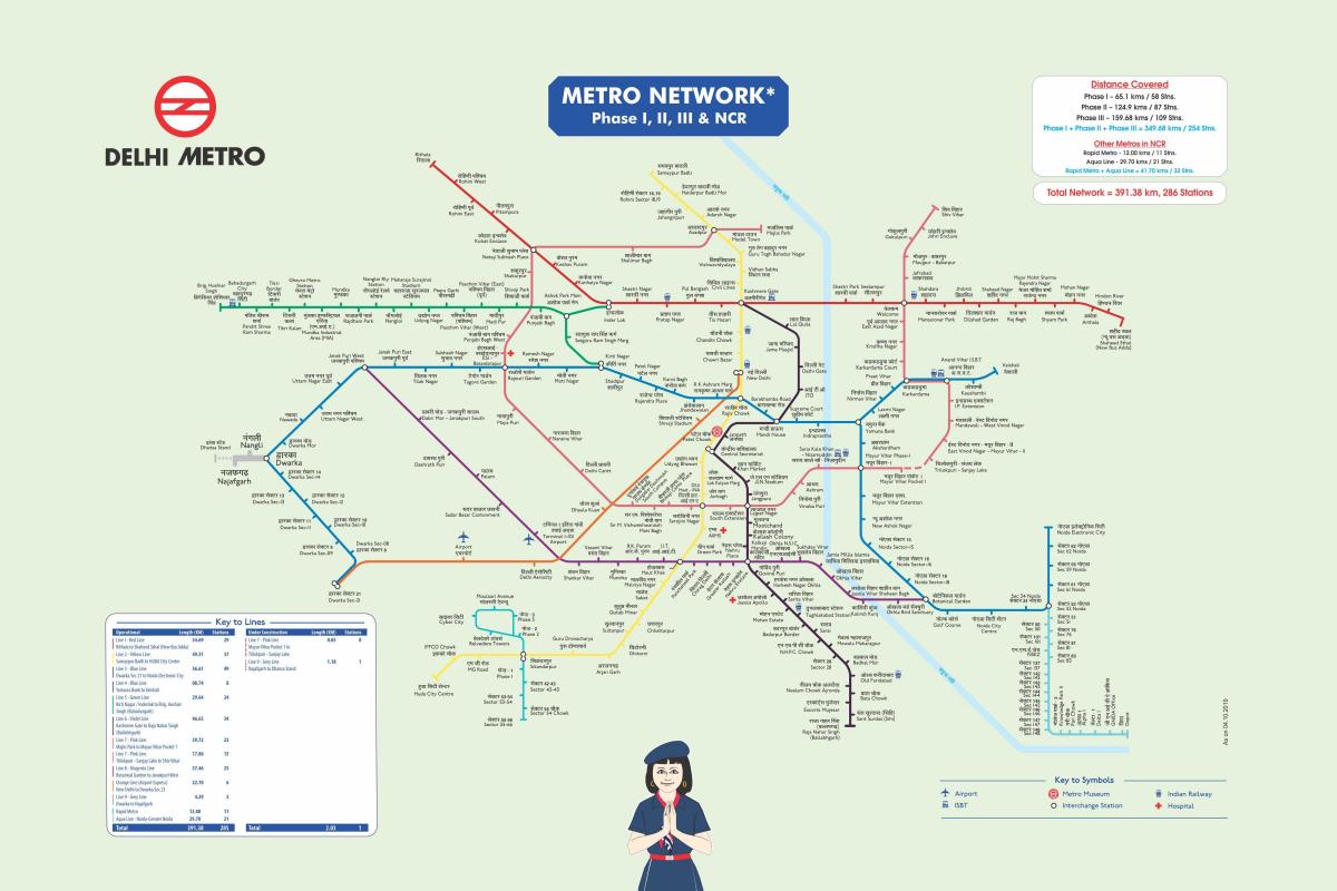
You can find on this page the New Delhi metro map to print and to download in PDF. The New Delhi metro map presents the network, zones, stations and different lines of the metro of New Delhi in India.
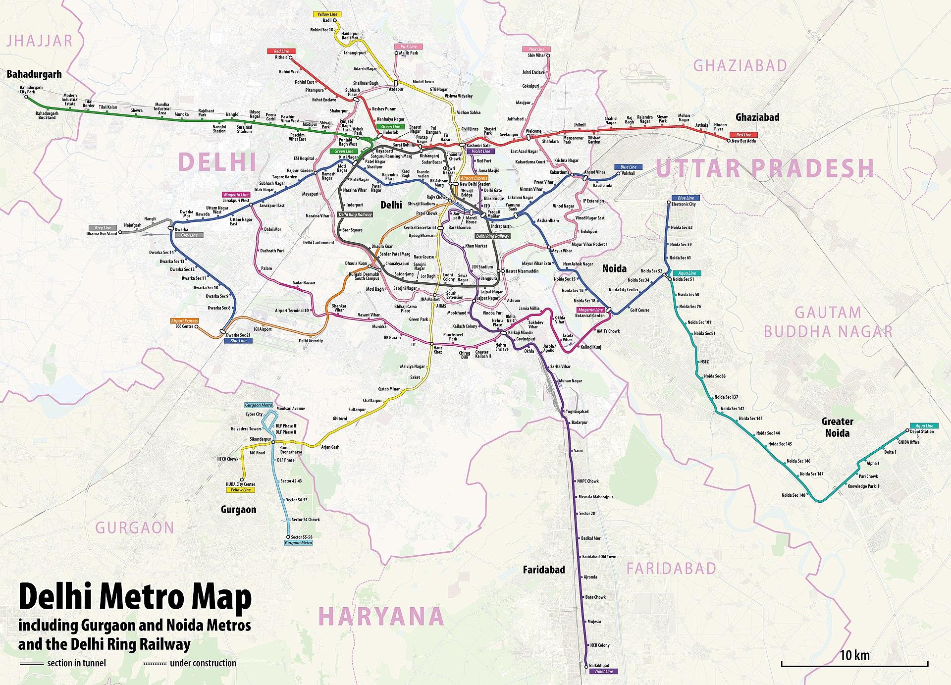
The New Delhi metro map shows all the stations and lines of the New Delhi metro. This metro map of New Delhi will allow you to easily plan your routes in the metro of New Delhi in India. The New Delhi metro map is downloadable in PDF, printable and free.
The Delhi Metro is a rapid transit system serving Delhi, Gurgaon, Noida and Ghaziabad in the National Capital Region of India as you can see in the Metro map New Delhi. The network consists of six lines with a total length of 189.63 kilometres (117.83 mi) with 142 stations of which 35 are underground. It has a combination of elevated, at-grade and underground lines and uses both broad gauge and standard gauge rolling stock. Four types of rolling stock are used: Mitsubishi-ROTEM Broad gauge, Bombardier MOVIA, Mitsubishi-ROTEM Standard gauge and CAF Beasain Standard gauge. The Delhi Metro Rail Corporation has been certified by the United Nations as the first metro rail and rail-based system in the world to get “carbon credits for reducing greenhouse gas emissions” and helping in reducing pollution levels in the city by 630,000 tons (630 Gg) every year.
Delhi Metro is being built and operated by the Delhi Metro Rail Corporation Limited (DMRC). As of November 2010, DMRC operates around 2,700 trips daily between 6:00 and 23:00 running with an interval of 2 minutes 30 seconds between trains at peak frequency as its shown in the Metro map New Delhi. The trains are mainly of four coaches, but due to increase in passengers numbers, six-coach trains are also added on the Red Line (Dilshad Garden to Rithala), Yellow Line (Jahangirpuri to HUDA city centre), Blue Line (Dwarka sec −21 to Vaishali/NOIDA city centre) and Violet Line (Central Secretariat to Badarpur). The power output is supplied by 25-kilovolt, 50 Hertz alternating current through overhead catenary. The metro has an average daily ridership of 1.8 million commuters, and, as of July 2011, had carried over 1.25 billion commuters since its inception.
The Delhi Metro is being built in phases. Phase I completed 65.11 km (40.46 mi) of route length, of which 13.01 km (8.08 mi) is underground and 52.10 km (32.37 mi) surface or elevated as its mentioned in the Metro map New Delhi. The inauguration of the Vaishali–Barakhamba Road corridor of the Blue Line marked the completion of Phase I on October 27, 2006. Phase II of the network comprises 128 km (80 mi) of route length and 79 stations, and is fully completed, with the first section opened in June 2008 and the last line opened in August 2011. Phases III (112 km) and IV (108.5 km) are planned to be completed by 2015 and 2021 respectively, with the network spanning 413 km (257 mi) by then.
The New Delhi subway map shows all the stations and lines of the New Delhi subway. This subway map of New Delhi will allow you to easily plan your routes in the subway of New Delhi en India. The New Delhi subway map is downloadable in PDF, printable and free.
The concept of a mass rapid transit for New Delhi first emerged from a traffic and travel characteristics study which was carried out in the city in 1969. Over the next several years, many official committees by a variety of government departments were commissioned to examine issues related to technology, route alignment and governmental jurisdiction (see New Delhi subway map). In 1984, the Delhi Development Authority and the Urban Arts Commission came up with a proposal for developing a multi-modal transport system, which would consist of constructing three underground mass rapid transit corridors as well augmenting the city existing suburban railway and road transport networks. While extensive technical studies and the raising of finance for the project were in progress, the city expanded significantly resulting in a twofold rise in population and a fivefold rise in the number of vehicles between 1981 and 1998. Consequently, traffic congestion and pollution soared, as an increasing number of commuters took to private vehicles with the existing bus system unable to bear the load.
The Red Line was the first line of the subway to be opened and connects Rithala in the west to Dilshad Garden in the east, covering a distance of 25.09 kilometres (15.59 mi) as you can see in New Delhi subway map. It is partly elevated and partly at grade, and crosses the Yamuna River between Kashmere Gate and Shastri Park stations. The inauguration of the first stretch between Shahdara and Tis Hazari on December 24, 2002, caused the ticketing system to collapse due to the line being crowded to four times its capacity by citizens eager to have a ride. The Yellow Line was the second line of the subway and was the first underground line to be opened. It runs for 44.36 kilometres (27.56 mi) from north to south and connects Jahangirpuri with HUDA City Centre in Gurgaon. The northern and southern parts of the line are elevated, while the central section through some of the most congested parts of Delhi is underground. The first section between Vishwa Vidyalaya and Kashmere Gate opened on December 20, 2004, and the subsequent sections of Kashmere Gate – Central Secretariat opened on July 3, 2005, and Vishwa Vidyalaya – Jahangirpuri on February 4, 2009.
The Blue Line was the third line of the subway to be opened, and the first to connect areas outside Delhi. Partly overhead and partly underground, it connects Dwarka Sub City in the west with the satellite city of Noida in the east, covering a distance of 47.4 kilometres (29.5 mi) as its shown in New Delhi subway map. Opened in 2010, the Green Line was the first standard-gauge corridor of the Delhi Metro. The fully elevated line connects Mundka with Inderlok, running for 15.1 kilometres (9.4 mi) mostly along Rohtak Road. An interchange with the Red line is available at Inderlok station via an integrated concourse. This line also has the country first standard-gauge maintenance depot at Mundka. The Violet Line is the most recent line of the Metro to be opened, and the second standard-gauge corridor after the Green Line. The 20.2 km (12.6 mi) long line connects Badarpur to Central Secretariat, with 9 km (5.6 mi) being overhead and the rest underground.